Sundarban

Sundarbans
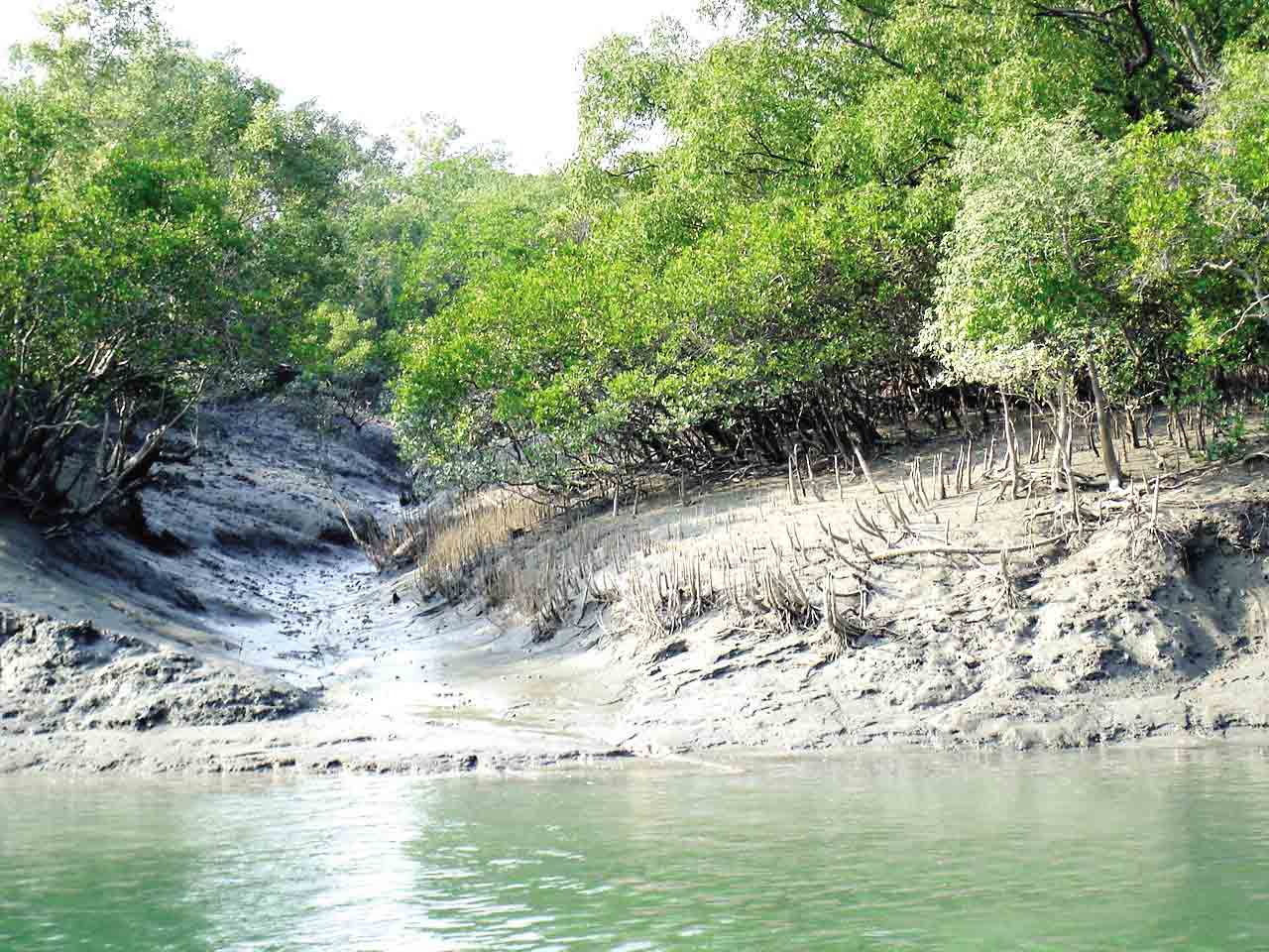
The Sundarbans mangrove forest, one of the largest such
forests in the world (140,000 ha), lies on the delta of the Ganges, Brahmaputra
and Meghna rivers on the Bay of Bengal. It is adjacent to the border of India’s
Sundarbans World Heritage site inscribed in 1987. The site is intersected by a
complex network of tidal waterways, mudflats and small islands of salt-tolerant
mangrove forests, and presents an excellent example of ongoing ecological
processes. The area is known for its wide range of fauna,
including 260 bird
species, the Bengal tiger and other threatened species such as the estuarine
crocodile and the Indian python.
Etymolog
The name Sundarban can be literally translated as "beautiful forest" in the Bengali language. The name may have been derived from the Sundari trees that are found in Sundarbans in large numbers. Alternatively, it has been proposed that the name is a corruption of Samudraban, Shomudrobon, or Chandra-bandhe. However, the generally accepted view is the one associated with Sundari or Sundri trees.
Sundarbans freshwater swamp forests

The Sundarbans freshwater swamp forests are a tropical moist
broadleaf forest ecoregion of Bangladesh. It represents the brackish swamp
forests that lie behind the Sundarbans Mangroves, where the salinity is
more pronounced. The freshwater ecoregion is an area where the water is only
slightly brackish and becomes quite fresh during the rainy season, when the
freshwater plumes from the Ganges and the Brahmaputra rivers push the intruding
salt water out and bring a deposit of silt. It covers 14,600 square kilometres
of the vast Ganges-Brahmaputra Delta, extending from the northern part of Khulna
District and finishing at the mouth of the Bay of Bengal with scattered portions
extending into India's West Bengal state.
 A victim of large-scale clearing and settlement to support
one of the densest human populations in Asia, this ecoregion is under a great
threat of extinction. Hundreds of years of habitation and exploitation have
exacted a heavy toll on this ecoregion's habitat and biodiversity. There are
two protected areas – Narendrapur (110 km2) and Ata Danga
Baor that cover a mere 130 km2
of the ecoregion. Habitat loss in this ecoregion is so extensive, and the
remaining habitat is so fragmented, that it is difficult to ascertain the
composition of the original vegetation of this ecoregion.
A victim of large-scale clearing and settlement to support
one of the densest human populations in Asia, this ecoregion is under a great
threat of extinction. Hundreds of years of habitation and exploitation have
exacted a heavy toll on this ecoregion's habitat and biodiversity. There are
two protected areas – Narendrapur (110 km2) and Ata Danga
Baor that cover a mere 130 km2
of the ecoregion. Habitat loss in this ecoregion is so extensive, and the
remaining habitat is so fragmented, that it is difficult to ascertain the
composition of the original vegetation of this ecoregion.Flora

The Sundarbans flora is characterised by the abundance of
sundari ,gewa ,goran and keora all of which occur prominently throughout the
area. The characteristic tree of the forest is the sundari, from which
the name of the forest had probably been derived. It yields a hard wood, used
for building houses and making boats, furniture and other things. New forest
accretions is often conspicuously dominated by keora and tidal forests. It is
an indicator species for newly accreted mudbanks and is an important species
for wildlife, especially spotted deer. There is abundance of dhundul or passur
and kankra though distribution is
discontinuous. Among palms, Poresia coaractata, Myriostachya
wightiana and golpata, and among grasses spear grass and khagra are well distributed.
The varieties of the forests that exist in Sundarbans
include mangrove scrub, littoral forest, saltwater mixed forest, brackish water
mixed forest and swamp forest. Besides the forest, there are extensive areas of
brackish water and freshwater marshes, intertidal mudflats, sandflats, sand
dunes with typical dune vegetation, open grassland on sandy soils and raised
areas supporting a variety of terrestrial shrubs and trees. Since Prain's
report there have been considerable changes in the status of various mangrove
species and taxonomic revision of the man-grove flora. However, very little
exploration of the botanical nature of the Sundarbans has been made to keep up
with these changes. Differences in vegetation have been explained in terms of
freshwater and low salinity influences in the Northeast and variations in drainage
and siltation. The Sundarbans has been classified as a moist tropical forest
demonstrating a whole mosaic of seres, comprising primary colonisation on new accretions
to more mature beach forests.
Fauna

There is much more wildlife here than just the endangered Bengal
tiger. Most importantly, mangroves are a transition from the marine to
freshwater and terrestrial systems, and provide critical habitat for numerous
species of small fish, crabs, shrimps and other crustaceans that adapt to feed
and shelter, and reproduce among the tangled mass of roots, known as pneumatophores,
which grow upward from the anaerobic mud to get the supply of oxygen. Fishing
cats, macaques, wild boars, common grey mongooses, foxes, jungle cats, flying
foxes, pangolins, and spotted deer are also found in abundance in the
Sundarbans.
A 1991 study has revealed that the Indian part of the
Sundarbans supports diverse biological resources including at least 150 species
of commercially important fish, 270 species of birds, 42 species of mammals, 35
reptiles and 8 amphibian species, although new ones are being discovered. This
represents a significant proportion of the species present in Bangladesh (i.e.
about 30% of the reptiles, 37% the birds and 34% of the mammals) and includes
many species which are now extinct elsewhere in the country. Two amphibians, 14
reptiles, 25 aves and five mammals are endangered. The Sundarbans is an
important wintering area for migrant water birds and is an area suitable for
watching and studying avifauna.
Mammals
The fertile
soils of the delta have been subject to intensive human use for centuries, and
the ecoregion has been mostly converted to intensive agriculture, with few
enclaves of forest remaining. The remaining forests, together with the
Sundarbans mangroves, are important habitats for the Bengal tiger. The forest
also provides habitat for small wild cats such as the jungle cat, fishing cat,and leopard cat.
 Several
predators dwell in the labyrinth of channels, branches and roots that poke up
into the air. This is the only mangrove ecoregion that harbours the
Indo-Pacific region's largest terrestrial predator, the Bengal tiger. Unlike in
other habitats, tigers live here and swim among the mangrove islands, where
they hunt scarce prey such as the chital deer ,Indian muntjacs ,wild boar, and rhesus
macaque.
It is estimated that there are now 180 Bengal tigers and about 30,000 spotted
deer in the area. The tigers regularly attack and kill humans who venture into
the forest, human deaths ranging from 30–100 per year.
Several
predators dwell in the labyrinth of channels, branches and roots that poke up
into the air. This is the only mangrove ecoregion that harbours the
Indo-Pacific region's largest terrestrial predator, the Bengal tiger. Unlike in
other habitats, tigers live here and swim among the mangrove islands, where
they hunt scarce prey such as the chital deer ,Indian muntjacs ,wild boar, and rhesus
macaque.
It is estimated that there are now 180 Bengal tigers and about 30,000 spotted
deer in the area. The tigers regularly attack and kill humans who venture into
the forest, human deaths ranging from 30–100 per year.Climate change
 The physical development processes along the coast are
influenced by a multitude of factors, comprising wave motions, micro and
macro-tidal cycles and long shore currents typical to the coastal tract. The
shore currents vary greatly along with the monsoon. These are also affected by cyclonic
action. Erosion and accretion through these forces maintains varying levels, as
yet not properly measured, of physiographic change whilst the mangrove
vegetation itself provides a remarkable stability to the entire system. During
each monsoon season almost all the Bengal Delta is submerged, much of it for
half a year. The sediment of the lower delta plain is primarily advected inland
by monsoonal coastal setup and cyclonic events. One of the greatest challenges
people living on the Ganges Delta may face in coming years is the threat of
rising sea levels caused mostly by subsidence in the region and partly by
climate change.
The physical development processes along the coast are
influenced by a multitude of factors, comprising wave motions, micro and
macro-tidal cycles and long shore currents typical to the coastal tract. The
shore currents vary greatly along with the monsoon. These are also affected by cyclonic
action. Erosion and accretion through these forces maintains varying levels, as
yet not properly measured, of physiographic change whilst the mangrove
vegetation itself provides a remarkable stability to the entire system. During
each monsoon season almost all the Bengal Delta is submerged, much of it for
half a year. The sediment of the lower delta plain is primarily advected inland
by monsoonal coastal setup and cyclonic events. One of the greatest challenges
people living on the Ganges Delta may face in coming years is the threat of
rising sea levels caused mostly by subsidence in the region and partly by
climate change.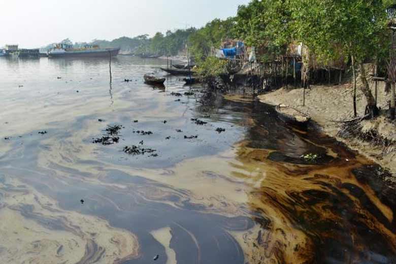 In many of the Bangladesh's mangrove wetlands, freshwater
reaching the mangroves was considerably reduced from the 1970s because of
diversion of freshwater in the upstream area by neighbouring India through the
use of the Farakka Barrage bordering Rajshahi, Bangladesh. Also, the Bengal Basin
is slowly tilting towards the east because of neo-tectonic movement, forcing
greater freshwater input to the Bangladesh Sundarbans. As a result, the
salinity of the Bangladesh Sundarbans is much lower than that of the Indian
side.
In many of the Bangladesh's mangrove wetlands, freshwater
reaching the mangroves was considerably reduced from the 1970s because of
diversion of freshwater in the upstream area by neighbouring India through the
use of the Farakka Barrage bordering Rajshahi, Bangladesh. Also, the Bengal Basin
is slowly tilting towards the east because of neo-tectonic movement, forcing
greater freshwater input to the Bangladesh Sundarbans. As a result, the
salinity of the Bangladesh Sundarbans is much lower than that of the Indian
side.In a study conducted in 2012, the Zoological Society of London (ZSL) found out that the Sunderban coast was retreating up to 200 metres (660 ft) in a year. Agricultural activities had destroyed around 17,179 hectares (42,450 acres) of mangroves within three decades (1975–2010). Shrimp cultivation had destroyed another 7,554 hectares (18,670 acres).
Researches from the School of Oceanographic Studies, Jadavpur University, estimated the annual rise in sea level to be 8 millimetres (0.31 in) in 2010. It had doubled from 3.14 millimetres (0.124 in) recorded in 2000. The rising sea levels had also submerged around 7,500 hectares (19,000 acres) of forest areas. This, coupled with an around 1.5 °C (2.7 °F) rise in surface water temperatures and increased levels of salinity have posed a problem for the survival of the indigenous flora and fauna. The Sundari trees are exceptionally sensitive to salinity and are being threatened with extinction.
A 2015 ethnographic study, conducted by a team of
researchers from Heiderberg university in Germany, found a crisis brewing in
the Sunderbans. The study contended that poor planning on the part of the India
and Bangladesh governments coupled with natural ecological changes were forcing
the flight of human capital from the region.
Sundarban National Park
 The Sundarban National Park is a National Park, Tiger
Reserve, and a Biosphere Reserve in West Bengal, India. It is part of the
Sundarbans on the Ganges Delta, and adjacent to the Sundarbans Reserve Forest
in Bangladesh. The delta is densely covered by mangrove forests, and is one of
the largest reserves for the Bengal tiger. It is also home to a variety of
bird, reptile and invertebrate species, including the salt-water crocodile. The
present Sundarbans National Park was declared as the core area of Sundarbans
Tiger Reserve in 1973 and a wildlife sanctuary in 1977. On 4 May 1984 it was
declared a National Park.
The Sundarban National Park is a National Park, Tiger
Reserve, and a Biosphere Reserve in West Bengal, India. It is part of the
Sundarbans on the Ganges Delta, and adjacent to the Sundarbans Reserve Forest
in Bangladesh. The delta is densely covered by mangrove forests, and is one of
the largest reserves for the Bengal tiger. It is also home to a variety of
bird, reptile and invertebrate species, including the salt-water crocodile. The
present Sundarbans National Park was declared as the core area of Sundarbans
Tiger Reserve in 1973 and a wildlife sanctuary in 1977. On 4 May 1984 it was
declared a National Park.

map..
https://www.google.com/maps/place/Sundarbans+National+Park/@21.837971,88.8849311,20z/data=!4m12!1m6!3m5!1s0x3a018264f05cd269:0xe99cba5218a4be78!2sSundarbans+National+Park!8m2!3d21.8379758!4d88.8851988!3m4!1s0x3a018264f05cd269:0xe99cba5218a4be78!8m2!3d21.8379758!4d88.8851988
Protection
The Bangladesh part of the forest lies under two forest divisions, and four administrative ranges viz Chandpai (Khulna District), Sarankhola (Khulna), and Burigoalini and has sixteen forest stations. It is further divided into fifty-five compartments and nine blocks. There are three wildlife sanctuaries established in 1977 under the Bangladesh Wildlife Order, 1973. The West Bengal part of the forest lies under the district of South & North 24 Parganas.
Protected areas cover 15% of the Sundarbans mangroves including Sundarbans National Park and Sajnakhali Wildlife Sanctuary, in West Bengal, Sundarbans East, Sundarbans South and Sundarbans West Wildlife Sanctuaries in Bangladesh.
Map


https://www.google.com/maps/place/Sundarbans/@22.0181325,88.7265054,9z/data=!3m1!4b1!4m5!3m4!1s0x3a004caac2c7b315:0x4716abcfbb16c93c!8m2!3d21.9497274!4d89.1833304
Comments
Post a Comment